

News Highlights:
The National Geospatial Policy 2022 recently notified to set up a high-resolution topographical survey and map with a high-accuracy Digital Elevation Model (DEM) for the country by 2030.
Key Takeaway:
- This is a vibrant initiative to promote the Start-Up & reduce the last mile dependencies on foreign soil.
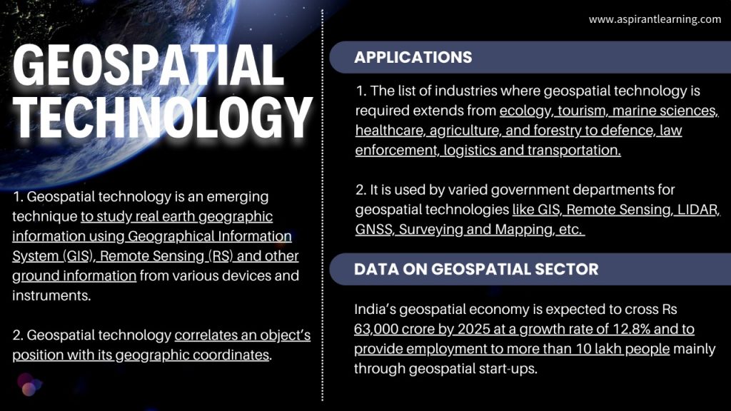
- India’s geospatial economy is expected to cross Rs 63,000 crore by 2025 at a growth rate of 12.8% and to provide employment to more than 10 lakh people.
Background:
- Guidelines:
- In 2021, the Ministry of Science and Technology issued “Guidelines for acquiring and producing Geospatial Data and Geospatial Data Services including Maps”.
- While the Guidelines deregulated the Geospatial sector by liberalising Geospatial data acquisition/production/ access, the 2022 Policy takes it further by laying down an overarching framework for the holistic development of the Geospatial ecosystem.
National Geospatial Policy 2022:
- About:
- It is a citizen-centric policy based on Geo-Spatial technology, which seeks to strengthen the Geospatial sector to support national development, economic prosperity and a thriving information economy.
- The policy aims to set up high-resolution topographical survey and mapping with a high-accuracy Digital Elevation Model (DEM) by 2030.
- Objectives:
- It will develop geospatial infrastructures, skills and knowledge, standards, and businesses.
- It aims to make India a World Leader in Global Geospatial space with the best in the class ecosystem for innovation.
- To develop a coherent national framework in the country and leverage it to move towards a digital economy and improve services to citizens.
- To promote innovation and strengthen the national and sub-national arrangements for generating and managing Geospatial information.
Geospatial Data Promotion and Development Committee (GDPDC):
- About:
- The Government will constitute a Geospatial Data Promotion and Development Committee (‘GDPDC’).
- It will be the apex body for formulating and implementing appropriate guidelines, strategies, and programs for promoting activities related to the Geospatial sector.
- Functions:
- Functions will take measures to foster innovation and provide leadership and coordination among stakeholders.
- It will also promote standards necessary to strengthen Geospatial information management so that they can be used to find sustainable solutions to the nation’s emerging development and security challenges.
- GDPDC Rules and procedures:
- GDPDC can frame rules and procedures for its business.
- In the absence of the Chairperson, Secretary, Department of Science & Technology, Government of India will preside over the Committee meetings.
- The Committee will meet at least once yearly as arranged by the Chairperson.
National Geospatial Policy’s Vision:
- Year 2025 goals:
- Put in place an enabling policy and legal framework that supports liberalisation of the Geospatial sector and democratisation of data for enhanced commercialisation with Value Added Services.
- Year 2030 goals:
- High-resolution topographical survey & mapping (5-10 cm for urban & rural areas and 50 cm-100 cm for forests & wastelands).
- Year 2035 goals:
- High resolution/accuracy Bathymetric Geospatial Data of inland waters and sea surface topography of shallow/deep seas – to support Blue Economy.
- National Digital Twin of major cities and towns. The Digital Twin is a virtual replica of a physical asset, process or service that lies at the core of the new digital revolution.
- National Digital Twin would be an ecosystem of intelligent, dynamic, connected Digital Twins, enabled by secure and interoperable data sharing, to facilitate better decision-making.
Significance of the Policy:
- Multi-Domain Applications:
- This technology has applications in every domain of the economy that enables government systems and services and sustainable national development initiatives to be integrated using ‘location’ as a common and underpinning reference frame.
- Citizen-centric policy:
- It is a citizen-centric policy that seeks to strengthen the Geospatial sector to support national development, economic prosperity, and a thriving information economy.
- Sustainable Development Goals:
- The focus of the Policy is to make Geospatial technology and data agents of transformation for achieving the Sustainable Development Goals to bring efficiency in all sectors of the economy and instil accountability and transparency at all levels of governance.
- Self-reliant:
- The Policy recognises the importance of locally available and locally relevant Maps and Geospatial Data in improved planning and management of resources and better serve the specific needs of the Indian population.
- It aims to create an enabling ecosystem, thereby providing a conducive environment to Indian Companies that will enable them to make India self-reliant in producing and using their Geospatial data and compete with foreign companies globally.
- Enhance Start-ups:
- The Policy enables and supports innovation, creation and incubation of ideas and start-up initiatives in the Geospatial sector that will enable leapfrogging from outdated regulations, technologies, and processes, bridging the Geospatial digital divide and capitalising on the opportunities arising out of continually evolving Technology.
Related Concerns:
- Complexity in Data:
- The data in Geospatial are complex data objects with complex relationships among them.
- Securing this type of data poses significant challenges and bottlenecks yet to be fully understood and addressed.
- Security Concerns:
- A variety of models and techniques are available to manage access and share geospatial data, little attention has been paid to addressing the National security concerns, such as access control, securities and privacy policies, the development of secure and, in particular interoperable GIS applications in the areas of Defence (Tri-Services).
- Data misuse:
- If the entire body of geospatial data is made available by simply integrating the data from the different repositories, there is severe chance of potential data misuse.
Way forward:
- There was a need to de-regularise the geospatial data policy in India.
- Several restrictions like getting licences or prior approvals have now been removed for the companies.
- There would be an increase in the development of made-in-India solutions, which modern geospatial technologies would back.
- The new policy has cleared the way for foreign companies to operate without any ambiguity while empowering Indian companies..
Pic Courtesy: Freepik
Content Source: Financial Express