
News Highlights:
- Recently, Indian Space Research Organisation (ISRO) released The Landslide Atlas of India at the “National Meet on Disaster Risk Management — Trends & Technologies” held at Hyderabad.
- Hyderabad-based National Remote Sensing Centre, one of the centres of ISRO, manages data from aerial and satellite sources to locate landslide-prone areas.
Key Findings:
- Landslide-vulnerable region:
- This report looked at landslide-vulnerable regions in 17 states and two Union Territories of India in the Himalayas and Western Ghats.
- Rajouri, Thrissur, Pulwama, Palakkad, Malappuram, South Sikkim, East Sikkim and Kozhikode in Kerala, Jammu Kashmir and Sikkim are other high-risk districts, found Landslide Atlas of India 2023.
- According to it, all 12 districts of Himachal Pradesh are prone to landslides.
- Around 0.18 million sq km of the landslide-prone areas in the country are in North East Himalayas, including Darjeeling and Sikkim Himalaya.
- Around 73 per cent of landslides in the Himalayan region are attributed to heavy rains and reduced water-absorbing capacity of the soil.
- Significance:
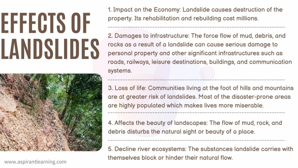
- This Atlas provides the details of landslides present in Landslide provinces of India, including damage assessment of specific landslide locations.
- The risk analysis in the report was based on the density of human and livestock populations, which indicates the impacts on people due to these landslides.
- The disaster in Kedarnath in 2013 and the landslides caused by the devastating Sikkim earthquake in 2011 are also included in this atlas.
Landslide:
- About:
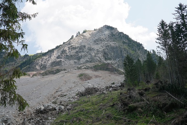
- A landslide is defined as the movement of a mass of rock, debris, or earth down a slope due to the action of gravity.
- Areas with steep slopes, for example, mountainous regions, are particularly susceptible to landslide hazards.
- Earth flow, mass movement, mudflow, rotational slip, and avalanches are all landslides.
- Types of Landslides:
- Falls: These happen due to the abrupt movements of the mass of geologic materials, such as rocks and boulders, that become detached from steep slopes or cliffs.
- Topples: It happens due to the forward rotation of a unit or units about some pivotal point under the actions of gravity and forces exerted by adjacent units or by fluids in cracks.
- Slides: In this type, rocks, debris, or soil slide through slope-forming material.
- Spread: It usually occurs on very gentle slopes or flat terrain.
- Landslides and India:
- Landslides and avalanches are among the major hydrogeological hazards that affect large parts of India.
- Around 15% of the country’s region is prone to landslides. The Himalayas of Northwest and Northeast India and the Western Ghats are two regions of high vulnerability.
- Some major recent incidents are in Kerala (2018), Himachal Pradesh (2018), Uttarakhand (2018), Tamenglong-Manipur (2018), and Kalikhola, Manipur (June 2017).
Causes of Landslides:
- Natural Causes:
- Climate: Soil stability may be significantly impacted by long-term climatic changes.
- Earthquakes: Seismic activities have, for a long time, contributed to global landslides. Any moment tectonic plates move, the soil covering them also moves along.
- Weathering: Weathering is the natural rock deterioration procedure leading to weak, landslide-susceptive materials.
- Erosion: Slope support is destroyed by erosion brought on by sporadic running water, such as streams, rivers, wind, currents, ice, and waves, which makes landslides more likely to happen.
- Volcanoes: Volcanic eruptions can trigger landslides. The stratovolcano is a typical example of a volcano responsible for most global landslides.
- Human causes:
- Mining: Landslides are greatly amplified by mining activities that use blasting techniques. The explosives’ vibrations can potentially damage the soil in other regions prone to landslides.
- Timber Harvesting: Clearcutting is a method of harvesting timber that involves cutting all old trees from the area. This method is hazardous since it completely destroys the local mechanical root system.
Mitigation:
- Restriction on the Construction in Certain Areas.
- Hazard mapping to locate areas prone to landslides.
- Some positive actions like promoting large-scale afforestation programs and the construction of bunds to reduce water flow.
- Terrace farming should be encouraged in the northeastern hill states where Jhumming (Slash and Burn/Shifting Cultivation) is still prevalent.
- To warn people residing in landslide-prone areas in advance.
- Advancements in scientific techniques will empower us to understand what factors cause landslides and how to manage them.
Pic Courtesy: Pixabay
Content Source: The Tribune