News Highlight:
Cyclone Mandous crossed the north Tamil Nadu coast close to Mamallapuram around Friday midnight, triggering heavy to very heavy rains in Chennai and neighbouring districts and gusty surface winds
Key Takeaway:
- The India Meteorological Department (IMD) said that the cyclonic storm Mandous landfall process was completed.
- Cyclone Mandous crossed the coast and is in deep depression, and it’s strength is weakening.
- It is moving towards Northwest direction so areas in northwest dists will witness strong winds of 55-65 kmph, further decreasing by evening to 30-40 kmph.
Several parts of Chennai are facing heavy rainfall and strong winds amid cyclone Mandous.
Cyclone Mandous:
- About:
- Cyclone Mandous is a slow-moving cyclone that often absorbs a lot of moisture, carries a humongous amount of rainfall and gains strength in the form of wind speeds.
- United Arab Emirates suggested the name.
- India Meteorological Department’s (IMD) predicted that the storm system may move in the west and northwestward directions and The well-marked low-pressure area over southeast Bay of Bengal intensified into a depression on December 6 and it further intensified into a “deep depression” and lay about 750 km off Chennai
- It may subsequently strengthen further into a cyclone over southwest Bay of Bengal and move towards the Tamil Nadu and Puducherry coasts by the morning of December 8.
Cyclones:

- About:
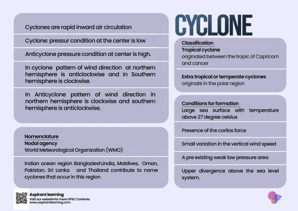
- A cyclone is a low pressure system that forms over warm waters. Essentially, it is a system of high speed winds rotating around a low-pressure area, with the winds blowing counterclockwise in the Northern Hemisphere and clockwise in the Southern Hemisphere.
- Violent storms and bad weather usually accompany cyclones.
- The word Cyclone is derived from the Greek word Cyclos meaning the coils of a snake. It was coined by Henry Peddington because the tropical storms in the Bay of Bengal and the Arabian Sea appear like coiled serpents of the sea.
- the area above the equator, which is the Northern hemisphere, it is called a Cyclone and rotates in an anticlockwise direction, whereas in the Southern hemisphere it is called a hurricane or typhoon and rotates in a clockwise direction.
- The main characteristic of Cyclones is that they move in a spiraling movement in an inward direction.
- Tropical Cyclones form over warm water in the tropical region of the ocean where hot air is heated by the sun, creating areas of very low pressure.
- Due to this, the air rises at a very high speed and gets saturated with the moisture that later forms the thunderclouds.
- Favourable Condition for tropical cyclone:
- A large sea surface area with a temperature above 27° C.
- The Coriolis force is present.
- The vertical wind speed varies slightly.
- A weak low-pressure area or low-level-cyclonic circulation that already existed.
- Above the sea level system, there is a higher divergence.
- Classification of Cyclones:
- Tropical cyclone:
- Tropical cyclones form over warm tropical oceans and intensify
- Tropical cyclones are intense storms that form over tropical areas and move to coastal areas, wreaking havoc with violent winds, torrential rainfall, and storm surges. It is one of the worst natural disasters ever
- In the Indian Ocean, they are known as cyclones
- Hurricanes occur in the Atlantic Ocean
- Typhoons concern the Western Pacific and the South China Sea
- Western Australia’s willy-willies.
- Extratropical cyclones:
- The front is initially immobile
- Warm air blows from the south and cold air from the north of the front in the Northern Hemisphere
- When the pressure drops along the front, warm air goes north and cold air moves south, causing an anticlockwise cyclonic circulation to form
- A well-developed extratropical cyclone with a warm front and a cold front results from the cyclonic circulation
- Warm air glides over cold air, causing precipitation as a series of clouds form across the sky ahead of the warm front
- The cold front pushes the warm air up as it approaches from behind. Cumulus clouds form along the cold front as a result
- The cold front advances quicker than the warm front and eventually overtakes it
- The cyclone evaporates as the warm air is totally lifted and the front is occluded
- Wind circulation activities at the surface and aloft are intricately interrelated.
- Polar Cyclones:
- It occurs in the northern hemisphere and is also called the Arctic hurricane. In this, the heat transforms the water into air and releases the latent heat, which further creates clouds. These types of Cyclones are difficult to predict as they take less than 24 hours to form.
- MesoCyclone:
- MesoCyclones are the most severe and powerful types of Cyclones that produce thunderstorms. In the convective storm, the mesoCyclone appears as a vortex. This vortex rotates along the vertical axis. In the given hemisphere, this airflow and the low-pressure system point the same way. And this mesoCyclone comes into formation by rotating air inside the thunderstorm.
- The nomenclature of the Cyclones:
- The World Meteorological Organisation maintains the nomenclature of the Cyclones.
- Indian ocean region which include Bangladesh,India, Maldives, Oman, Pakistan, Sri Lanka and Thailand contribute to name cyclones that occur in this region.
- Tropical cyclone:
Cyclones in India:
- Water bodies on all three sides surround India, and all the water bodies act as a hotspot for Cyclones.
- Some states, like Gujarat, Tamil Nadu, Kerala, Odisha, and West Bengal, are more prone to Cyclones.
- Since these Cyclones are accompanied by plentiful rain and high-speed winds, they become more deadly.
- Strom surges, strong winds, and torrential rains cause immense destruction to the surroundings.
Pic Courtesy: Freepik
Content Source: The Hindu


