Key Takeaways
- Andaman and Nicobar Islands to get gas powered plants as the Union Environment Ministry has approved an exemption to the laws governing the regulation of coastal zones.
Background of Development Move in Andaman and Nicobar Islands
- In the aftermath of a proposal from the Andaman and Nicobar Coastal Zone Management Authority (ANCMZA), an expert body of the Ministry of Environment and Forests, called the National Coastal Zone Management Authority (NCZMA), recommended in August 2021 that it was necessary to provide an “enabling provision in the ICRZ notification” to meet the energy requirement of the islanders while reducing the dependence on highly polluting energy sources such as conventional diesel generator (DG) sets.
- The NCZMA has recommended that it be permitted within the Island Coastal Regulation Zone area only on islands with geographical areas greater than 100 sq. km.
Where is it implemented?
- The Andaman and Nicobar administration is expected to commission a 50-MW power project running on liquefied natural gas at Hope Town, Port Blair, to be developed by the National Thermal Power Corporation (NTPC).
- Diesel is necessary, the Andaman administration authorities argued, as a back-up fuel when the region faced inclement weather.
About Andaman and Nicobar Islands
- Andaman and Nicobar islands were formed due to collision between the Indian plate and Burma minor plate , so it is continental island of Bay of Bengal.
- They are southward extension of Arakan Yoma range of Myanmar.
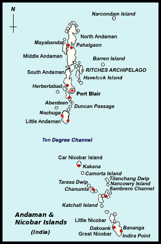
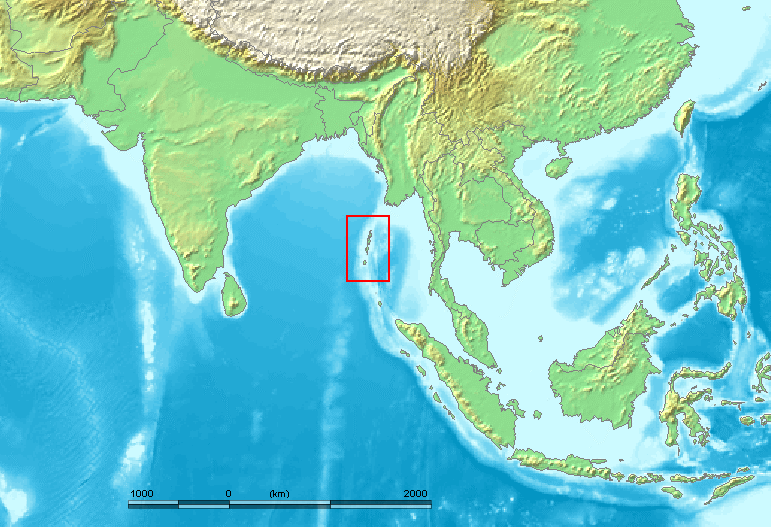
- The Andaman and Nicobar Islands, located in the Bay of Bengal, are a short band running north-south between 6° 45′ N and 13° 45′ N.
- Around 265 large and tiny islands make up this archipelago.
- The Andaman Islands are separated into three groups: North, Middle, and South.
- Capital – Port Blair
| Straits | Separated Islands |
| Duncan passage | Little Andaman from South Andaman |
| Ten Degree Channel | Andaman islands from Nicobar islands |
| Grand Channel | Great Nicobar islands and the Sumatra islands of Indonesia |
| Coco Strait | North Andaman islands and the Coco Islands of Myanmar |
- The Great Nicobar is the largest of the Nicobar islands. It is Indonesia’s southernmost island, and it is relatively close to Sumatra. Car Nicobar is the farthest north.
- Volcanic Islands
- Barren Island – Active volcano
- Narcondam Island – Extinct Volcano ( Home for IUCN vulnerable Narcondam Hornbill)
- The highest peak in North Andaman is Saddle Peak (737 m).
- The tropical marine climate of the Andaman and Nicobar Islands is influenced by the seasonal flow of monsoon winds.
- The area is covered with thick tropical rain forests. Mangrove forests can be found along the shore.
- The Giant Robber Crab, the world’s largest and rarest crab, is also found on the islands and is home to IUCN vulnerable Dugong.
- There are several uninhabited islands. Also poorly populated are the inhabited islands.
- Because it is located in a significant earthquake zone, the entire region is prone to earthquakes.
- Southernmost point of the island and India is Indira point located in Great Nicobar.
- Primitive tribes in islands – Jarawas, Onges , Jangil , Shompen , Sentinelese.

Significance of Andaman and Nicobar Islands
- The Andaman and Nicobar Islands are found where the Bay of Bengal meets the Andaman Sea.
- The Andaman and Nicobar Islands are located approximately 450 nautical miles north of the western entrance to the Malacca Strait, which is a key Indian Ocean chokepoint.
- The Andaman and Nicobar Islands are a geopolitical link between South Asia and South-East Asia. The archipelago’s northernmost point is only 22 nautical miles from Myanmar, while the archipelago’s southernmost point, Indira Point, is only 90 nautical miles from Indonesia.
- The islands dominate the Bay of Bengal, as well as the Six Degree and Ten Degree Channels, which see over 60,000 commercial ships pass through each year.
- Although the Andaman and Nicobar Islands make up only 0.2 percent of India’s landmass, they account for about 30% of the country’s Exclusive Economic Zone.
- It acts as a check on China’s influence in the Indo – Pacific region.
Threats Face by Andaman and Nicobar Islands
- Sea level rise and climate change
- Unsustainable development
- Militarization of region
About Island Coastal Zone Regulation (ICRZ)
- Its goal is to conserve and protect the unique environment of coastal stretches and marine areas, as well as to provide livelihood security to fishermen and other coastal communities, and to promote sustainable development based on scientific principles, taking into account natural hazards and sea level rise due to global warming.
- In light of this, the NCSCM has created draught Island Coastal Regulation Zone Plans on a 1: 25000 scale in accordance with the ICRZ Notification 2019. The following items have been included in the draught Plan:
- ICRZ – IA (Ecological Sensitive Areas),
- ICRZ – IB (Inter Tidal Zone),
- ICRZ III (Undeveloped Area),
- ICRZ – IV (Water Area),
- The eight larger oceanic islands in Andaman and Nicobar (ICRZ Islands) shall be grouped as follows:
- Group-I: Islands with geographical areas >1000 sq.km such as South Andaman, Middle Andaman, North Andaman and Great Nicobar.
- Group-II: Islands with geographical areas >100 sq.km but < 1000 sq.km such as Baratang, Little Andaman, Havelock and Car Nicobar.
- For Group-I Islands, the land area extends from the High Tide Line (hence referred to as the HTL) to 200 meters on the landward side of the sea front, while for Group-II Islands, it extends to 100 meters.
Content Source : The Hindu


